


Our Main Office
Construction Equipment Guide
470 Maryland Drive
Fort Washington, PA 19034
800-523-2200
Wed February 09, 2022 - National Edition
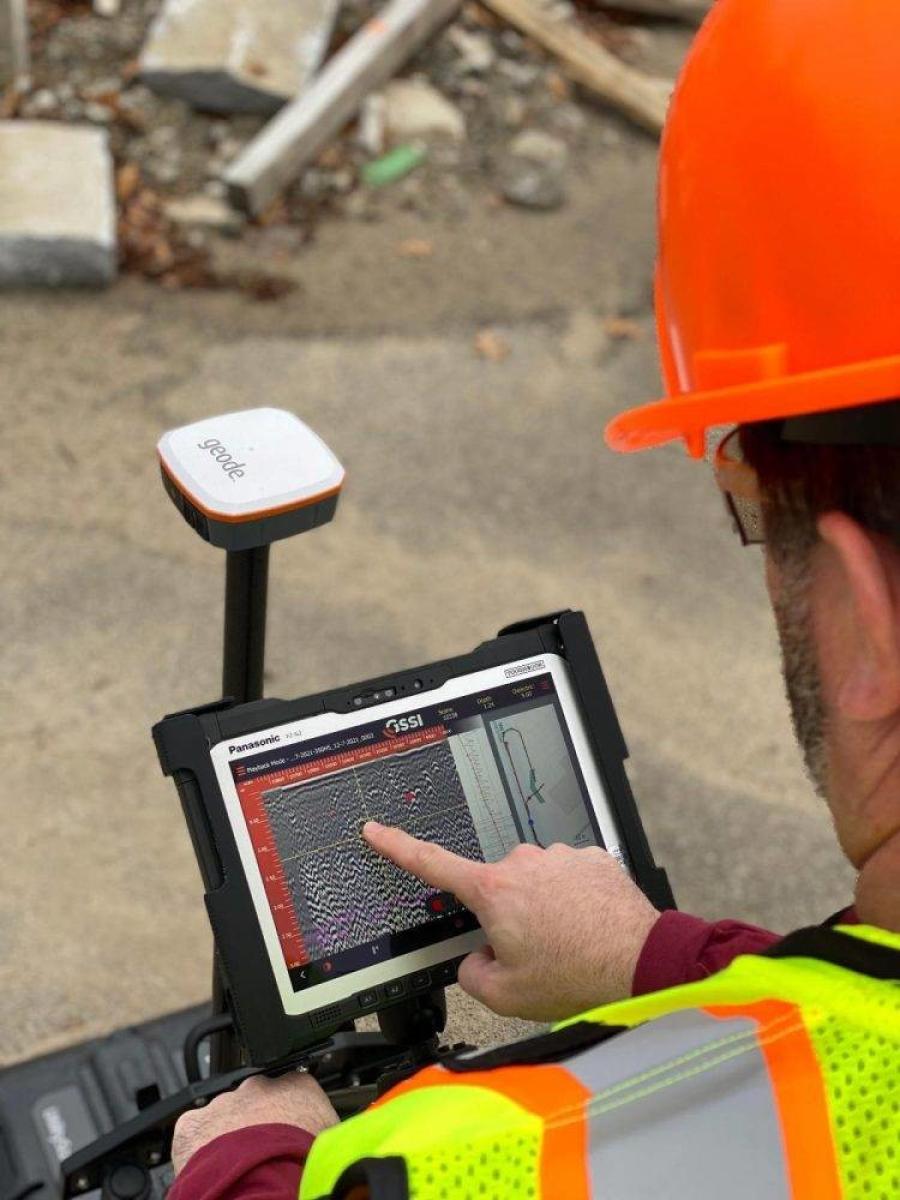
GSSI, a leading manufacturer of ground penetrating radar (GPR) equipment, announced the updated UtilityScan GPR system, with a new user interface (UI) that makes it easier than ever to locate and mark the depth of underground utilities in real-time in the field.
With real-time target mapping, advanced scanning and identification capabilities, the rugged and flexible UtilityScan helps utility locating professionals accelerate workflow from target detection to reporting.
UtilityScan is ideal for marking the location and depth of subsurface utilities, including gas, sewer, and communication lines. Real-time target mapping features include a new map mode that allows users to trace their steps and gain a bird's-eye view of their survey.
Users also can simultaneously place APWA color-coded marks on 2D data and a geo-referenced map.
With the updated UI, users can collect and create 3D scans. The on-screen 3D data collection mode allows users to easily define the time slice depth and thickness in the field with the 3D data on the screen. The map window can be minimized to view the 3D display full screen.
The rugged, flexible system is rated IP65, with durable components tested to withstand the most challenging survey environments, including rain, dust and extreme cold down to 4 F. The integrated Panasonic G2 tablet screen is designed for rain and glove use.
For areas where Wi-Fi is prohibited, the system includes a rugged Ethernet cable that can be used for communication between the tablet and antenna.
UtilityScan is available with the optional LineTrac power detection module, which enables identification and tracing of the precise location of underground electric and RF-induced utilities. This allows the detected power or induced frequencies data to be overlaid on the radar data, providing reliable positioning and target information.
This system is compact and portable, only weighing 34 lbs.
For more information, visit www.geophysical.com/products/utilityscan or email GSSI at sales@geophysical.com.
Construction Equipment Guide
470 Maryland Drive
Fort Washington, PA 19034
800-523-2200
Construction Equipment Guide covers the nation with its four regional newspapers, offering construction and industry news and information along with new and used construction equipment for sale from dealers in your area. Now we extend those services and information to the internet. Making it as easy as possible to find the news and equipment that you need and want.
Contents Copyrighted 2024, by Construction Equipment Guide, which is a Registered Trademark, registered in the U.S. Patent Office. Registration number 0957323. All rights reserved, nothing may be reprinted or reproduced (including framing) in whole or part without written permission from the publisher. All editorial material, photographs, drawings, letters, and other material will be treated as unconditionally assigned for publication and copyright purposes and are subject to Construction Equipment Guide’s unrestricted right to edit and comment editorially. Contributor articles do not necessarily reflect the policy or opinions of this publication.
Read our privacy policy here.
Mastodon