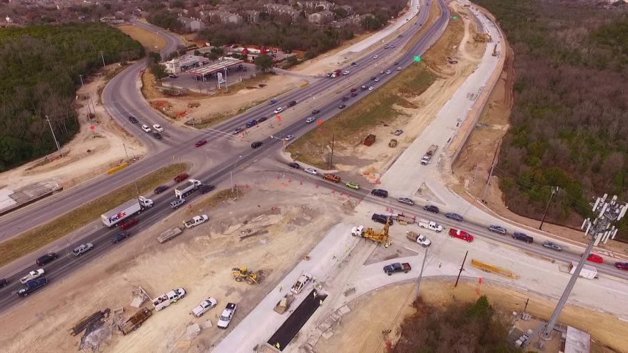
The project includes the construction of two tolled lanes in each direction, an adjacent shared use path from Hero Way to Seward Junction Loop and aesthetic enhancements along the corridor.
In April, the Lane Construction Corporation began efforts to reconstruct the Central Texas Regional Mobility Authority's (Mobility Authority) 183A Phase III Project, a $277.3 million initiative that is extending the 183A Toll Road 6.6-mi. northward from Hero Way in Leander to north of SH 29 in Liberty Hill to provide greater mobility and connectivity for commuter and commercial traffic.
Lane Construction was awarded the "design-bid-build" delivery method contract at $175.7 million last September. Phase III was developed in partnership with a number of government agencies in central Texas, including the Texas Department of Transportation and the Capital Area Metropolitan Planning Organization (CAMPO).
The project, financed by the Mobility Authority, includes the construction of two tolled lanes in each direction, an adjacent shared use path from Hero Way to Seward Junction Loop and aesthetic enhancements along the corridor. The new lanes will be located between the existing non-tolled frontage roads, mitigating disruption to the traveling public during construction.
Construction Progress
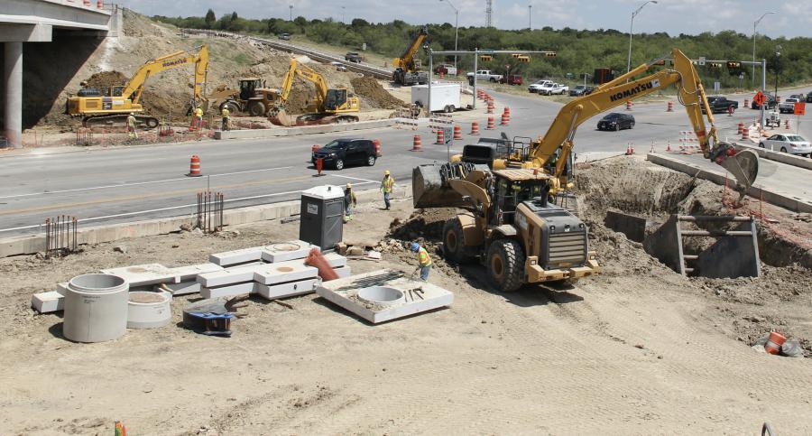
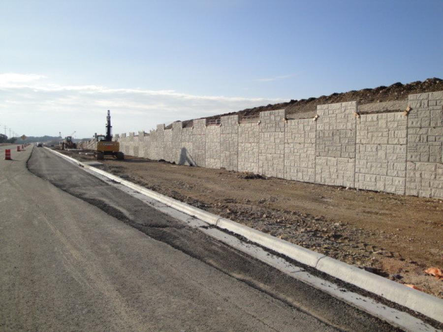
Thus far, crews have started work on underground storm drainage, bridge piers, pavement markings, traffic control barrier, clearing operations, jack and boring and waterline improvements. The remainder of this year's construction season will focus on bridge overpass and MSE wall construction, storm drain installation, earthmoving activities and water quality/ detention pond construction.
One of the beneficial aspects of this project is that the majority of construction will take place within the large median of the existing roadway. The use of this space and barrier walls helps to ensure separation between construction and the traveling public In addition, most of the construction will take place during off-peak, daytime hours to minimize traffic impacts; Phase III is purposefully designed and managed to minimize disruption to the public and increase safety for all who travel and work within the project limits.
Construction challenges are anticipated, but Lane Construction is confident it can master them. It stressed that like any typical project of this nature, challenges and constraints are inevitable and that construction doesn't occur in a vacuum. The entire team is working together to account for various variables from the very beginning and help mitigate potential delays and conflicts. Lane is working closely with the Mobility Authority on scheduling and coordination on utilities along a particular segment which controls the critical path of the project to ensure successful project delivery.
Prefabricated elements are being used to build the new infrastructure. These include concrete bridge beams and bridge deck panels, mechanically stabilized earth walls, and steel trusses and overlook platforms for a pedestrian bridge on the San Gabriel River. Right now, construction requires the installation of precast drainage structures that will include precast inlets, junction chambers, drainage pipe and box culverts.
Utility relocation is ongoing, and the project team is working closely with the city of Georgetown and other third-party utility owners to relocate waterlines for the roadway's expansion. Both the project design and construction contract accounted for these utility relocations and therefore, they are not expected to impact project delivery.
Communications with Lane are critical to ensure benchmarks are being met. Lane, the CEI and the Mobility Authority have a great working relationship, and open and transparent communication is proving to be a successful recipe, according to the Mobility Authority.
At present, there are approximately 70 Lane and subcontractor personnel on-site. The main subcontractors are Ranger Excavating for earthwork activities; Beaird Drilling for bridge drill shafts; SICE for electrical and signage components; D Guerra Construction for waterline utilities; and Oscar Orduno for temporary special shoring.
The project team doesn't foresee using any new materials. The amounts of materials to be generated through excavation and demolition and new materials to be brought in are still being tabulated and considered. A ballpark estimate for materials includes more than 230,000 tons of concrete and more than 21,000 tons of asphalt paving.
The 2022 season will deal with a continuation and start of bridge overpass and MSE wall construction, storm drain installation, earthmoving activities, water quality/detention pond construction and temporary shoring activities.
Project's Need
Due to unprecedented regional growth, most notably in Cedar Park, Leander and Liberty Hill, the Mobility Authority projects that traffic volumes along U.S. 183 are expected to increase nearly 200 percent by 2042, which is the driving force for this proactive congestion relief project.
"Williamson County, most notably in Cedar Park, Leander and Liberty Hill, is experiencing a population boom," said Mike Sexton, the Mobility Authority's acting director of engineering. "Between 2016 and 2040, Cedar Park's population is projected to grow by 31 percent, Liberty Hill by approximately 44 percent and Leander by 271 percent. The corridor is expected to continue to attract residential and commercial development, further intensifying congestion and delays.
"Increased congestion along the existing U.S. 183 corridor could negatively impact the safety, with crashes more likely to occur at a greater frequency and severity level at cross street intersection locations," he added. "In addition, projections show that increased congestion would result in unreliable travel times negatively impacting the quality of life regionally."
Bobby Jenkins, chairman of the Mobility Authority board of directors, is pleased that Phase III is happening.
"We're proud to be ahead of the curve on this project," said Jenkins. "Just as we delivered meaningful relief with the initial phases of 183A, extending the roadway will accommodate future growth and ensure that the mobility needs of our region are met long into the future. This project will not only meet the capacity demands that projected growth is sure to bring, but it will also ensure long-term reliability and connectivity."
The Phase III extension is building on the success of the existing 11-mi. 183A Toll Road, which goes from RM 620 through Cedar Park.
"The project, which consists of tolled mainlanes with non-tolled frontage roads at the north end, has significantly improved travel times and reduced traffic on adjacent roadways, including U.S. 183," said Lloyd Chance, the Mobility Authority's assistant director of engineering, construction. "Phase III will provide a reliable, predictable and time-saving option for drivers and emergency vehicles, accommodate community growth and development along and to the north of the corridor, provide an alternative route without signalized intersections, and minimize community impacts by working mostly within existing right-of-way."
Previous Changes
Phase I, a tolled roadway between RM 620 and RM 1431, with non-tolled frontage roads from RM 1431 northward to the San Gabriel River, opened in March 2007. Phase II, a 5-mi. extension northward from RM 1431 to Hero Way, opened in April 2012 and resulted in a significant shift of traffic from the non-tolled frontage roads to the new tolled mainlanes. Phase II was completed more than seven years ahead of schedule and had the immediate effect of reducing gridlock and travel times.
Non-tolled operational improvements and enhancements to the U.S. 183/183A (North) intersection were delivered in 2015 to make "it safer and easier to navigate and to enable better access to developments along 183A," stated the project web page. "The 183A Toll shared use path includes a 10-foot-wide, 7-mile long dedicated bicycle and pedestrian path that borders the 183A facility from South Brushy Creek to Hero Way. It also includes a trailhead and pedestrian bridge that crosses Brushy Creek, as well as a connection to Williamson County's Brushy Creek Regional Trail. Phase III of the 183A system will extend the shared use path north from Hero Way to Seward Junction Loop."
"Phase III is designed to build upon this success," said Chance. "The project is anticipated to open to traffic in 2025, freeing up capacity on U.S. 183 and adjacent roadways."
A virtual groundbreaking ceremony for the project was held on April 28 due to COVID restrictions, which featured many stakeholders.
"We are so excited about 183A Phase III getting going," said Williamson County Commissioner Cynthia Long. "Our economy and overall quality of life relies on the ability to travel to and from our communities."
With construction to occur primarily within the existing 183A and U.S. 183 right-of-way, the traffic management plan is based on temporary lane closures, primarily during off- peak hours and associated with the construction of entrance/exit ramps and grade separated intersections.
"In order to minimize noise from construction activities, the project team will follow a set of guidelines designed to preserve quality of life for adjacent neighborhoods," said Chance. "We measure the success of our projects, not just by their outcome, but by how we go about delivering increased mobility to our central Texas community." CEG
Irwin Rapoport
A journalist who started his career at a weekly community newspaper, Irwin Rapoport has written about construction and architecture for more than 15 years, as well as a variety of other subjects, such as recycling, environmental issues, business supply chains, property development, pulp and paper, agriculture, solar power and energy, and education. Getting the story right and illustrating the hard work and professionalism that goes into completing road, bridge, and building projects is important to him. A key element of his construction articles is to provide readers with an opportunity to see how general contractors and departments of transportation complete their projects and address challenges so that lessons learned can be shared with a wider audience.
Rapoport has a BA in History and a Minor in Political Science from Concordia University. His hobbies include hiking, birding, cycling, reading, going to concerts and plays, hanging out with friends and family, and architecture. He is keen to one day write an MA thesis on military and economic planning by the Great Powers prior to the start of the First World War.
Read more from Irwin Rapoport here.
Today's top stories


