


Our Main Office
Construction Equipment Guide
470 Maryland Drive
Fort Washington, PA 19034
800-523-2200
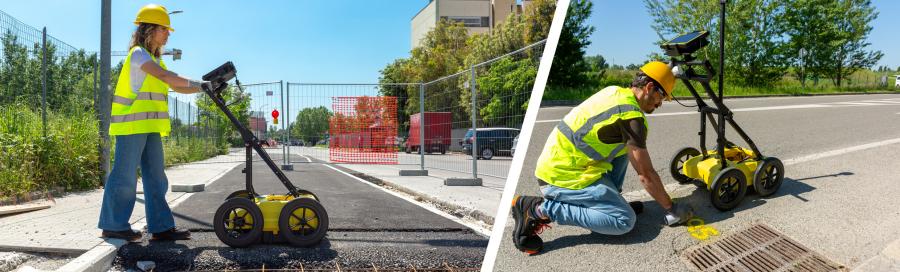
Leica's DS4000 utility detection system, utilizing IDS GeoRadar's technology, can identify underground assets up to 60 percent deeper than traditional systems. It reveals smaller objects like fiber optic cables, improving efficiency and safety for construction projects in congested urban areas.
Mon June 16, 2025 - National Edition
Leica Geosystems announced the launch of the Leica DS4000.
This utility detection system can identify underground assets up to 60 percent deeper than traditional systems, according to Leica. By integrating IDS GeoRadar's patented equalised scrambling technology (EsT), it detects underground utilities more clearly at both shallow and deeper levels. It even reveals smaller objects that could have been missed before, such as fibre optic cables, according to Leica.
Beneath the ground lies a tangled network of cables and pipes. As urban spaces — and the ground beneath them — grow more congested, advanced underground detection systems have become essential for reducing risk before breaking ground.
"The DS4000 helps teams work more efficiently, confidently and safely," said Matthias Twardzik, director, Hexagon Detection of Hexagon's Geosystems division. "With increasing emphasis on safety, tighter regulations and more complex projects, precise underground utility detection is becoming even more critical. With the DS4000, surveyors can deliver accurate data in complex environments and construction or utilities teams can reduce risk, avoid costly setbacks during excavation and keep their timelines on track."
Being lightweight and portable, the DS4000 is easy and safe for a single person to transport and operate. The wheels can be quickly swapped out, enabling one user to tackle both flat surfaces and rough terrain without interruption, according to Leica.
Furthermore, the antenna, which extends below the cart, is mounted on an automatic height-adjusting system that lowers it for detection and raises it to avoid obstacles, reducing the risk of damage.
For more information, visit leica-geosystems.com/en-us/products/detection-systems/utility-detection-solutions/leica-ds4000-utility-detection-radar
Construction Equipment Guide
470 Maryland Drive
Fort Washington, PA 19034
800-523-2200
Construction Equipment Guide covers the nation with its four regional newspapers, offering construction and industry news and information along with new and used construction equipment for sale from dealers in your area. Now we extend those services and information to the internet. Making it as easy as possible to find the news and equipment that you need and want.
Contents Copyrighted 2025, by Construction Equipment Guide, which is a Registered Trademark, registered in the U.S. Patent Office. Registration number 0957323. All rights reserved, nothing may be reprinted or reproduced (including framing) in whole or part without written permission from the publisher. All editorial material, photographs, drawings, letters, and other material will be treated as unconditionally assigned for publication and copyright purposes and are subject to Construction Equipment Guide’s unrestricted right to edit and comment editorially. Contributor articles do not necessarily reflect the policy or opinions of this publication.
Read our privacy policy here.
Mastodon
